|
|
No.
cortazzi012
Nickname.
|
|
資料名(日):
TERRE DE IESSO
|
|
資料名(英):
TERRE DE IESSO
|
|
画像頁G:
|
|
所蔵:
成立・出版年(西暦):
1683
成立・出版年(和暦):
出版地(日):
パリ
|
|
出版者(日):
|
|
出版者(英):
|
|
作成者(日):
|
|
作成者(英):
Manesson-Mallet, A
|
|
アトラス・書名:
Description | de | L’Univers, | contenant | Les differents systemes du monde, | les Cartes generales & particuliers de la geographie |. . .| Dediee au Roy. | Par Allain Manesson Mallet, | . . . | (printer’s device) A Paris, | Chez Denys Thierry, rue S. Jacques, a l’Enseigne | de la Ville de Paris, devant la rue du Platre. | M. DC. LXXXIII. | Avec Privilege du Roy.
|
|
版画家(日):
メディア(日):
銅版画
|
|
地図サイズ:
14.5×10.5 cm
メディア(英):
-
エリア(日):
蝦夷
|
|
出版特権:
|
|
地図備考(日):
|
|
地図備考(英):
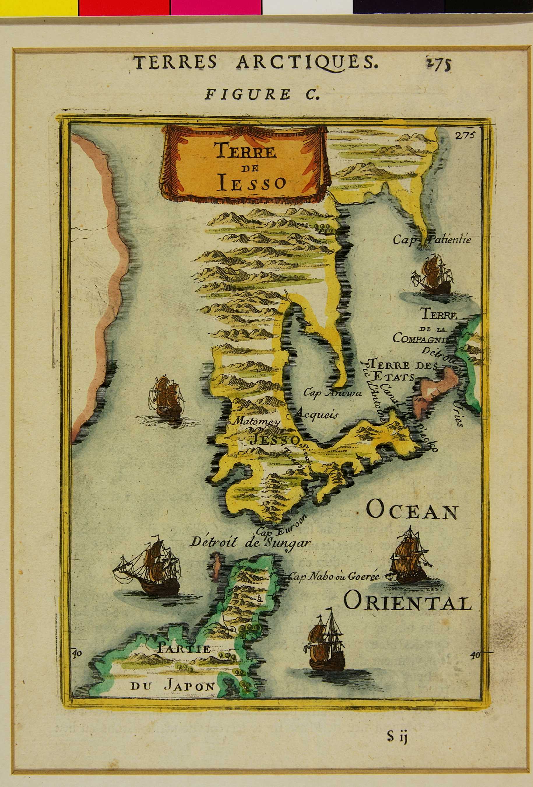
(Walter:) This is the first Western map that is exclusively devoted to Ezo. It is not part of the description of Japan in Mallet's work (cf. cat. no. 63), rather it is contained in the volume that treats the regions of the northern hemisphere. It shows the discoveries of the Dutchman Maerten Gerritsz. Vries in 1643, which were first incorporated in a map of Japan by Janssonius in 1651 (cf. cat. nos. 55, 57). Kunashiri is, therefore, also depicted here as the continuation of the Nemuro Peninsula. Etorofu (Iturup) is Referred to here as "Terre des Etats" and the western side of Urup as "Terre de la Compagnie". The northern part of the eastern coast of Ezo as shown with "Cap Aniwa" and "Cap Patientie" actually belongs to southern Sakhalin. The depiction of the northern tip of Honsh? is striking in that it deviates from Mallet's map of Japan that is contained in the same book (cf. cat. no. 63).
|
|
地図解説(日):
|
|
地図注釈(日):
|
参考文献(英):
> List of References
|
追加の参考文献(日):
> List of References
|
|
|
|
地図の位置:
LC
Shelfmark:
G1015.M33 1683 vault
|
|
|
|
|
|
所蔵資料の利用に関しましては所蔵資料ご利用ガイドをご覧ください。
If you wish to use any of the images from our databases for purposes other than personal use, please click here.
|
|